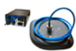
Parametric sub-bottom profiler

Parametric sub-bottom profiler (PPF) allows to carry out works on stratification of a bottom; search, detection or research of various objects located in a water column, on a bottom surface and also in a thickness of precipitation.
The use of parametric antennas as a source of acoustic signals, as well as due to the high-directional broadband radiation of low-frequency signals, it is possible to obtain a very high resolution for this frequency range with good penetration. Another advantage of the parametric profilographs constructed in this way is that, due to the constancy of the directional characteristics in a wide frequency range, they sound the same area within a narrow beam of the difference low-frequency signal at all frequencies, ensuring the reliability of the measured parameters.
The complex is designed for profiling the seabed at depths from 10 m to 50 m and the power of the soil layer up to 20 m with a resolution of up to 20 cm. Complex is placed on board a moving vessel (ship, boat, boat, etc.). The complex is used on all rivers, lakes and shelf seas, oceans. It is possible to use the complex at deep depths (depending on the type of soil).
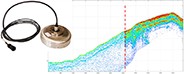
The complex operates under the control of software (hereinafter referred to as SOFTWARE) installed on the computer of the complex. As the vessel moves, the water column and the bottom are probed, echoes are received and recorded on a storage device (archiving). Simultaneously, in real time on the computer screen, the Operator can observe the resulting acoustic image (AI) - sonogram. The measurement and recording of the vessel's position and coordination data are synchronized with the space sensing. The availability of this information, together with a specially prepared plan of the campaign allows the Operator to quickly assess the adequacy of the amount of information received, and, if necessary, to conduct repeated or additional tacks. This can save time and money compared to having to return to the survey area after the data has been processed. Obtaining AI, primary processing of information and its archiving for further use is carried out in the process of shooting. Before shooting, it is recommended to carry out preparatory work and activities to ensure its quality. After the survey is completed, secondary (in-house) processing of the data obtained during the survey and the creation of various reports can be carried out.
With the help of the complex you can perform a variety of tasks:
- Search for various sunken objects on the bottom surface, in the bottom sediments (silted objects). High resolution and wide field of view allow to search for underwater objects, significantly reducing time and material costs. Especially effective is the use of the complex in muddy water, where optical means do not give results. The mobility of the complex allows you to start work as soon as possible, which is especially important in emergency rescue operations.
- Engineering and environmental monitoring. The high quality of the obtained AI allows the complex to be used effectively in the preparation of construction and inspection of underwater parts of various structures (including pipelines), both at the construction stage and during operation.
- Preparation and construction of hydrotechnical structures, inspection and control of the current state. With the help of the complex, the tasks of preparing the construction of port facilities, oil rigs, pipelines for various purposes, communication lines, etc., as well as the tasks arising in the course of their operation are solved. During the construction and operation of underwater structures, the complex allows for inspection in order to control the quality of construction, prevent dangerous situations, which ultimately reduces the risk of man-made disasters.
- Special and scientific research. The versatility of the complex in the field of signal generation and processing, as well as the ability to work at different depths allow a wide range of studies in almost any water area.
Download product catalogue
![]() Hydra models. Brief description (tb00005) Size: 12.59 MB
Hydra models. Brief description (tb00005) Size: 12.59 MB
Additional information
Expansion kit, additional equipment and accessories
Functional and methods of bottom profiling
end faq